
Pin Code Map of India – Understanding the Nation’s Postal Network
The Pin Code Map of India is an important geographical and administrative tool that helps identify postal regions, sorting districts, and delivery zones across the country. A PIN (Postal Index Number) is a six-digit code used by India Post to streamline mail delivery and eliminate confusion caused by similar place names, language differences, and incomplete addresses. The PIN system was introduced on 15 August 1972 and has since become an essential part of communication, logistics, e-commerce, and government administration in India.
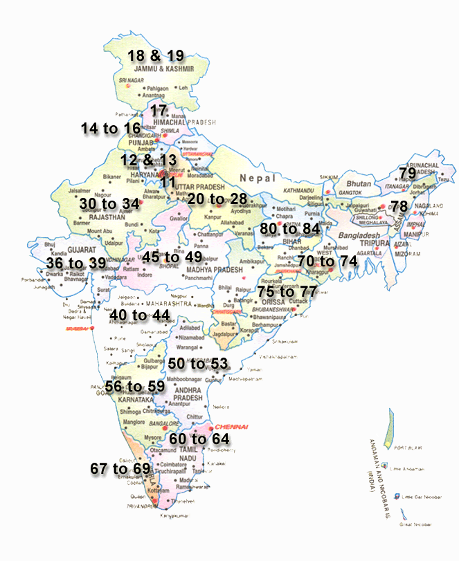
A pin code map visually represents the distribution of postal zones throughout India. By looking at the map, users can quickly identify the postal region to which a particular state, city, town, or village belongs. The map is especially useful for businesses, logistics providers, researchers, government agencies, and citizens who need accurate location information for deliveries and correspondence.
India’s PIN code system is organized hierarchically. The first digit indicates one of the country’s major postal zones, while the second digit identifies a sub-region or postal circle. The third digit represents a sorting district, and the final three digits designate a specific post office responsible for mail delivery in that area. This structure enables efficient sorting and routing of millions of letters and parcels every day.
The first digit divides India into nine postal zones, including eight geographical zones and one functional zone dedicated to the Army Postal Service. For example, PIN codes beginning with “1” cover Delhi, Punjab, Haryana, Himachal Pradesh, Chandigarh, Jammu & Kashmir, and Ladakh, while codes beginning with “6” are assigned to Tamil Nadu, Kerala, Puducherry, and Lakshadweep. Similarly, codes starting with “7” cover West Bengal and most of the northeastern states, whereas “8” represents Bihar and Jharkhand.
The Pin Code Map of India also reflects the vastness and diversity of the nation’s postal network. From metropolitan cities such as Delhi, Mumbai, Chennai, Kolkata, Bengaluru, and Hyderabad to remote villages in the Himalayas and the Northeast, every area is connected through a unique postal identity. This extensive network enables reliable delivery of mail, official documents, financial services, and e-commerce shipments across the country.
In the digital age, the significance of pin codes has expanded beyond postal services. Online shopping platforms, courier companies, banks, insurance firms, and government portals use PIN codes for address verification, service availability checks, delivery estimates, and location-based analytics. As a result, the PIN code map has become an indispensable reference for both businesses and consumers.
In conclusion, the Pin Code Map of India is far more than a postal reference. It is a reflection of the country’s organized communication infrastructure and serves as a critical tool for logistics, commerce, governance, and everyday life. By understanding how PIN codes are distributed across the map, users can gain valuable insight into India’s vast and interconnected postal system.