
Geological Map of India
India’s geological landscape records an extraordinary history extending from ancient crystalline rocks formed during the earliest chapters of Earth’s evolution to young river sediments that continue to accumulate today. A geological map represents this history through colours, patterns and boundaries denoting different rock groups, geological ages and structural regions. The map on this page offers a simplified visual introduction to the principal geological formations found across the Indian subcontinent.
Understanding India’s Geological Structure
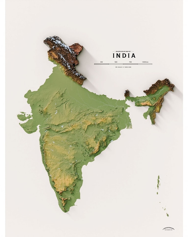
At a broad level, the geology of India may be understood through three major physical and geological domains: the ancient Peninsular region, the Himalayan mountain system and the sediment-covered Indo-Gangetic-Brahmaputra plains. Within these broad domains are volcanic provinces, sedimentary basins, mineral-bearing belts and coastal deposits created by geological processes operating over immense periods of time.
The Peninsular Shield
Peninsular India forms the ancient and comparatively stable geological core of the country. It contains extensive areas of granite, gneiss, schist and other igneous and metamorphic rocks. Important geological provinces include the Dharwar, Singhbhum, Bastar and Bundelkhand regions, along with younger sedimentary systems such as the Cuddapah and Vindhyan basins.
These old rocks preserve evidence of crustal formation, volcanic activity, mountain building, deformation and metamorphism. Their varied mineral composition has also made the Peninsular region important for deposits of iron ore, manganese, gold, bauxite and several other metallic and industrial minerals. The Geological Survey of India maintains extensive geological, petrological and mineral-exploration records for these terrains.
The Himalayan Geological Belt
The Himalayas form a much younger and tectonically active geological region. They developed through the continuing interaction of the Indian and Eurasian tectonic plates, which folded, faulted and uplifted rocks that had formed in different environments and geological periods.
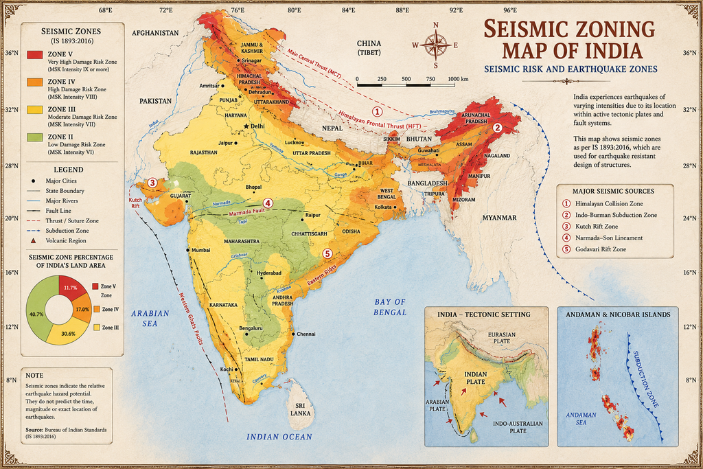
The range contains several parallel geological zones separated by major faults and thrust systems. These structures, together with steep slopes, active rivers and intense seasonal rainfall, contribute to the region’s susceptibility to earthquakes, landslides and erosion. Research by the Wadia Institute of Himalayan Geology and other scientific organisations continues to examine mountain-building processes, active faults, glaciers and natural hazards across the Himalayan region.
The Indo-Gangetic-Brahmaputra Plains
The broad northern plains are largely covered by alluvium deposited by the Indus, Ganga, Brahmaputra and their tributaries. These sediments include layers of sand, silt, clay and gravel transported from the Himalayas and adjoining uplands.
Because the sediment cover is thick and comparatively young, much of the underlying bedrock is not visible at the surface. The plains are among India’s most productive agricultural regions and contain major groundwater systems. However, the nature, depth and permeability of sediment layers can vary considerably from one place to another.
The Deccan Volcanic Province
A large part of western and central India is covered by the Deccan Traps, an immense succession of basaltic lava flows created by repeated volcanic eruptions near the end of the Cretaceous Period. The term “trap” is derived from a word meaning steps, referring to the staircase-like landscape produced by erosion of successive lava layers.
The Deccan volcanic sequence extends mainly across Maharashtra, Madhya Pradesh, Gujarat and adjoining areas. The Geological Survey of India describes the surviving lava province as covering more than 500,000 square kilometres, with the cumulative lava pile exceeding 2,000 metres in some areas. Weathering of these basaltic rocks has contributed to the formation of the dark soils widely associated with parts of the Deccan Plateau.
Sedimentary Basins and Younger Rock Systems
The map also identifies major sedimentary formations such as the Gondwana, Vindhyan and Cuddapah systems, along with Tertiary and younger deposits near the coasts, river valleys and northeastern India.
Gondwana basins contain thick sedimentary sequences associated with ancient continental environments and include many of India’s important coal-bearing areas. Sedimentary rocks also provide information about past rivers, lakes, seas, climates and ecosystems. Their texture, porosity and permeability are particularly relevant to groundwater studies, petroleum geology and the movement of fluids through the subsurface.
How to Read the Geological Map
Each colour on a geological map normally represents a particular rock unit, geological period or group of related formations. Lines may indicate contacts between rock units, while additional symbols can show faults, folds, mineral occurrences or other geological features.
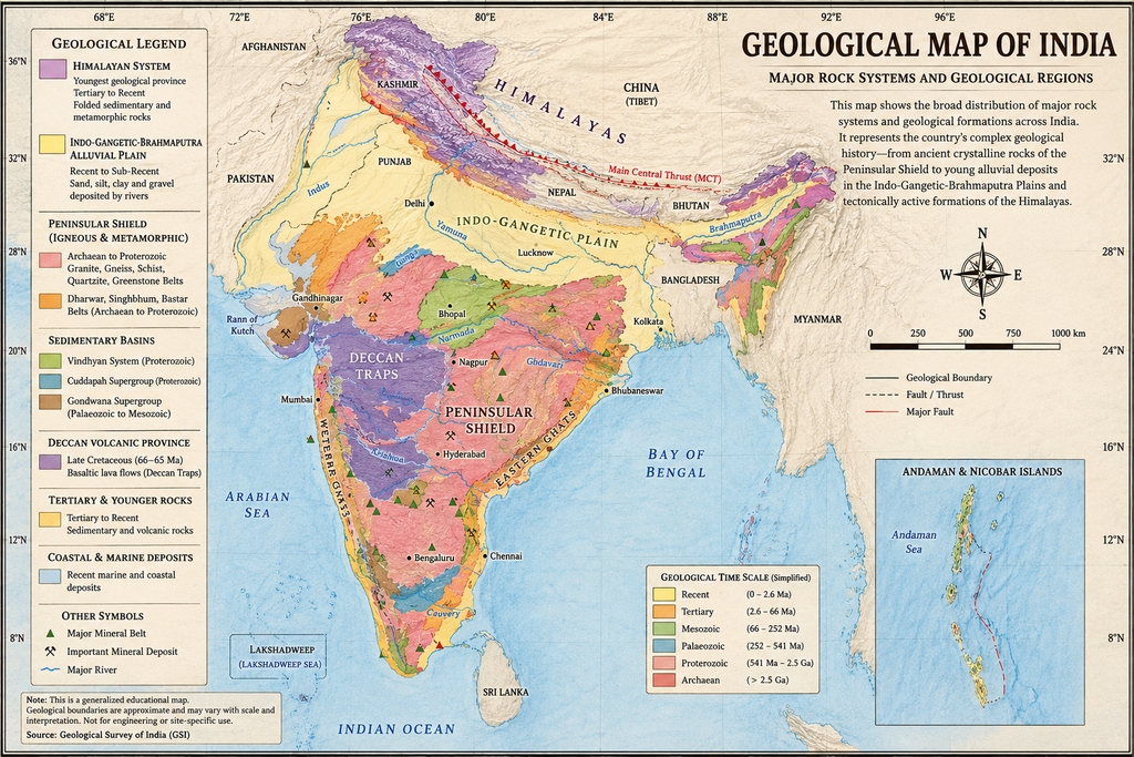
The colours should therefore be interpreted through the accompanying legend rather than as political or physical boundaries. A region shown in one colour may also contain smaller geological units that are not visible at the scale of a national map. Detailed geological interpretation requires larger-scale maps, field observations, rock samples, subsurface information and geophysical data.
Why India’s Geology Matters
Geology influences far more than the rocks visible at the surface. It affects the availability of minerals and groundwater, the formation of soils, the shape of landscapes and the location of natural hazards. Geological information supports mineral exploration, infrastructure planning, groundwater assessment, environmental management, earthquake studies and landslide-risk reduction.
India’s formal geological maps, specialised publications and regional mineral-resource studies are produced and maintained principally by the Geological Survey of India. The GSI publication system includes map series, regional geological reports, thematic studies and geological and mineral-resource publications for different states.
Map Note
This is a generalised educational map intended to introduce the broad geological pattern of India. Geological boundaries and classifications may vary according to map scale, survey date and subsequent scientific interpretation. It should not be used for engineering design, mineral claims, land development, groundwater drilling or hazard assessment without consulting current, location-specific data from the Geological Survey of India and other competent authorities.