
India Map – 1700s
This absolutely gorgeous map, whose title translates to The City of Kochi located on the coast of Malabar, was created in the early 1700s to help sea-traders travelling from other regions to Coetsjien (Kochi). The map was a hand-coloured copper engraving by Francois Valentijn, an explorer and naturalist from the Netherlands who wrote about the history of the Dutch East Indian company and chronicled the countries of the Far East. His maps were considered very valuable, and his narrative style made him known as a prominent Dutch writer of his time.
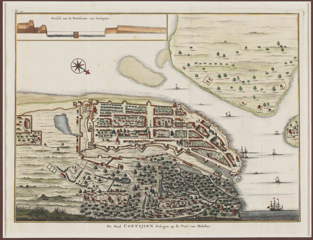
The coastal map shows the dock as well as the landmass from a bird’s-eye vantage point. The dock entry is fortified and the embankment runs all along in the inland, embracing the fort of Kochi. The unfortified section, meanwhile, represents the local residences, filled with tiny waterways, streams, places of worship and vegetation. The top left of the map has an illustration of a profile view of the dock entry, to give travellers a clearer idea about the elevation. The elaborate attention to detail and the almost toy-like drawing style makes this map irresistible.
Even though Bombay (present-day Mumbai) was the centre of trade and commerce in Colonial India, strangely very few early maps survive of the region. This particular map, created in the 1700s by well-known French cartographer Jacques-Nicolas Bellin, is a rare exception. Bellin used the earlier nautical maps of the ‘Island Of Bombay and Sallset’ by Samuel Thornton which were created to aid mariners, and added new information to his version.
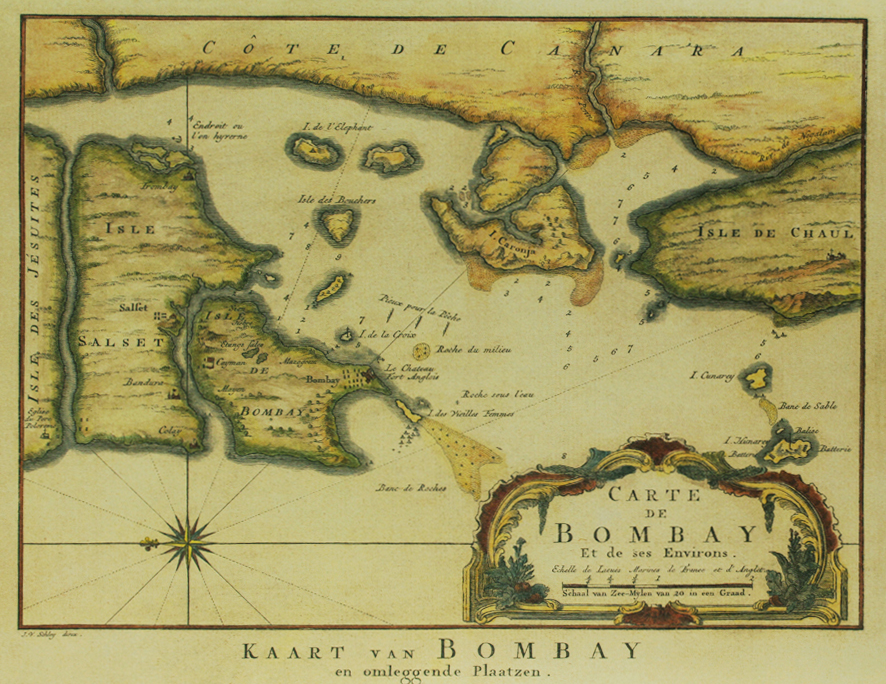
The map shows the Islands of Bombay and Salset, and has a unique section marked the ‘Isle des Jésuites’ on the extreme left. It is possible that this is present-day Vasai (Portuguese Bassein), as the area had a large Jewish population in the early colonial era. In the ‘Isle Salset’ and the ‘Isle De Bombay’ various important trading/residential points are marked — look out for Bandura (Bandra), Mazagoem (Mazgaon), Sion, Majem (Mahim), Fort Anglois (Fort), Isle des Vielles Femmes (Colaba or the Old Women’s Island) and Isle de l’Elephant (Elephanta Island).
On the right side of the map is a portion marked out as Isle de Chaul, which was a Portuguese town colonised around 1521 with a fort built in the region. Today, the village of Chaul lies in ruins near the town of Revanda, in the Raigarh district of Maharashtra. The presence of numbers and navigational pointers drawn over the sections showing water bodies suggests that this too was a nautical map drawn for the benefit of seafarers.
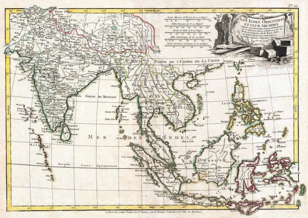
Map of India and Southeast Asia – East Indies (ca. 1770s)
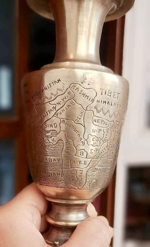
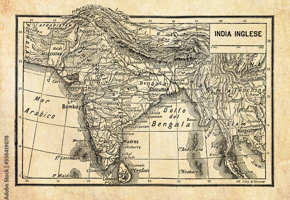
Ancient map of British Empire in India or British Raj on the Indian subcontinent, formed by India, Pakistan, and Bangladesh with geographical Italian names and descriptions
A new general map of the East Indies : exhibiting in the Peninsula on this side of the Ganges, or Hindoostan, the several partitions of the Mogul’s Empire ; and the dominions of the English East India Company in the provinces of Bengal, Bahar, Orixa, as well as upon the coasts of Malabar and Coromandel ; with the French and Dutch possessions according to the peace of 1783 : and in the peninsula beyond the Ganges, the kingdoms of Assam, Cashar, Aua, Aracan, Mien, Pegu, Siam, Lao and Cambodia, &c.
This historical document is an Italian-produced map titled India Inglese (British India), dating from the late 19th or early 20th century. Unlike the earlier British surveys, this map represents a crucial transition from a fragmented landscape of independent kingdoms to a consolidated, unified subcontinent under the British Raj. It clearly defines the borders of British-controlled territories alongside princely states, meticulously plotting the growing infrastructure of the colonial empire, including major administrative centers like Bombay, Madras, and the capital at Calcutta.
This map captures an important step in shaping India’s future by establishing the unified geographical, administrative, and political framework of the modern nation. By consolidating hundreds of fractured princely realms and regional factions into a single, standardized cartographic entity, the map laid the physical blueprint for the borders of modern India. Furthermore, the heavily emphasized transportation networks, major river valleys, and coastal ports shown here formed the backbone of the integrated national railway, telegraph, and economic infrastructure. While drawn to serve colonial governance and commerce, this deliberate integration inadvertently fostered a shared geographic identity among the population, binding diverse regions together and laying the structural foundation for a unified, independent Indian state in 1947.
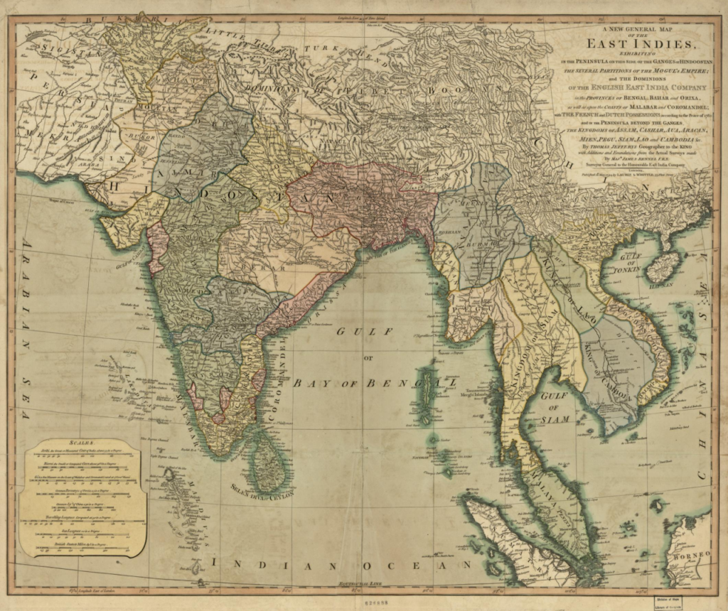
This historical document is A New General Map of the East Indies, originally engraved by the royal cartographer Thomas Jefferys and later updated with the groundbreaking surveys of James Rennell for publication by Laurie & Whittle in 1794. Originally designed to reflect the territorial agreements of the Treaty of Paris, this specific edition integrates the advanced geographic data compiled during Rennell’s tenure as the first Surveyor-General of Bengal from 1767 to 1777. Rennell’s deep connection to India as an officer with the Bengal Engineers revolutionized regional cartography; he systematically unified local route surveys with historical Mughal administrative divisions to provide the British Empire with unprecedented strategic clarity. The map splits the region into Hindoostan Proper and the Southern Peninsula, utilizing hand-tinted outline coloring to visually isolate the rapid expansion of the British East India Company across Bengal, Bihar, and Orissa from competing regional powers like the Maratha Empire and the Nizam of Hyderabad. By stretching eastward to detail the kingdoms of Southeast Asia, including Siam and Cambodia, this publication underscored the shifting colonial ambitions and maritime trade networks anchoring British influence in Asia during the late 18th century.
Hindoostan – 1782
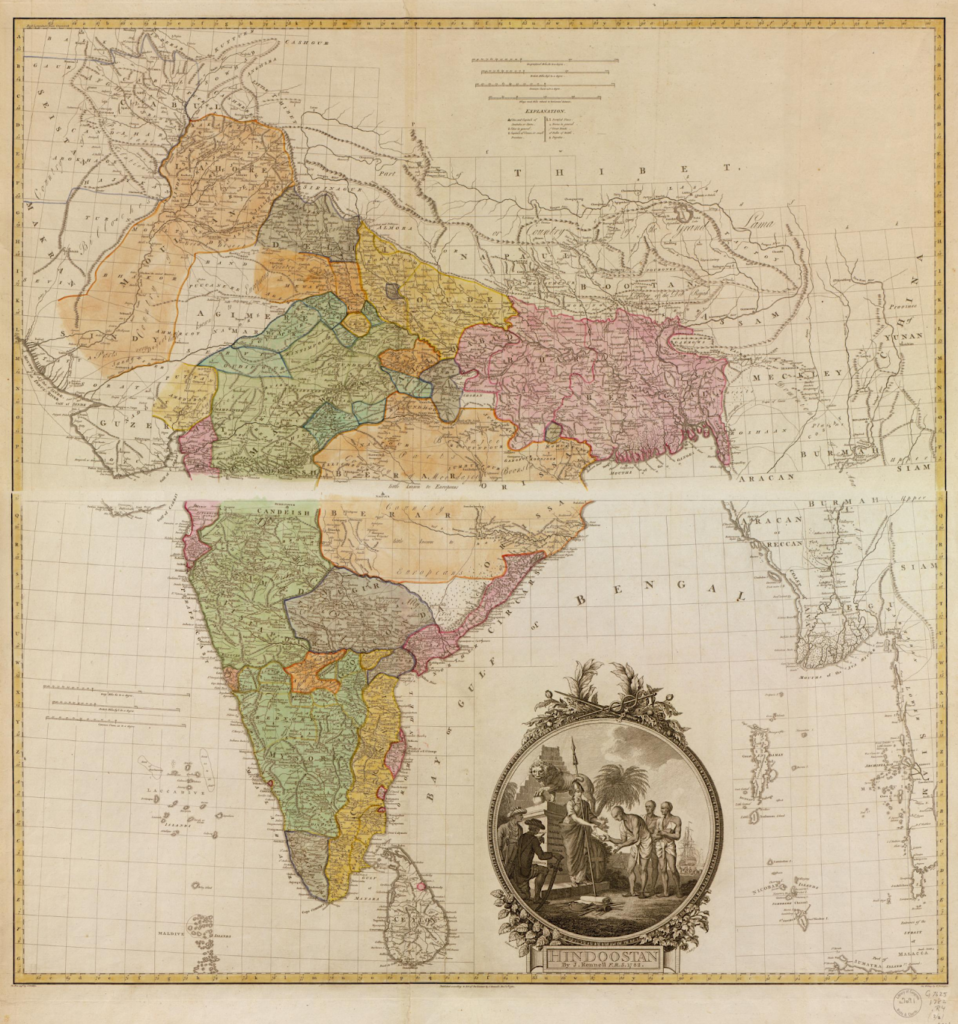
This historical artifact is the landmark Map of Hindoostan, which was meticulously drafted by the leading British geographer and cartographer James Rennell and first published in 1782. Commissioned by Robert Clive, the victor of the Battle of Plassey, Rennell was tasked with producing an expansive survey because the British East India Company required detailed geographic information to control and administer its rapidly expanding territories. Rennell had a deep personal connection to India, serving as an officer with the Bengal Engineers and later being appointed as the first Surveyor-General of Bengal from 1767 to 1777. Often revered as the “Father of Indian Cartography,” his scientific methods—which combined route measurements, astronomical control points, and a specialized grid system—resulted in the first approximately accurate and comprehensive map of the entire subcontinent. The elaborate decorative vignette at the bottom right reflects the era’s imperial sentiment, visually symbolizing native submission by depicting Brahmins presenting sacred Shastra texts to a figure representing Britannia
Hindoostan Proper: The upper section covers the Northern plains and the weakening core of the Mughal Empire. Prominent regional shading defines areas like Oude (Awadh), Bahar (Bihar), and the extensive Bengal region, alongside the Sikh territories in the northwest and Rajpootana (Rajasthan).
Peninsular India: The lower section partitions the southern subcontinent into the Deccan plateau and regions further south. This includes the formidable Maratha Empire spanning central India, the realms of the Nizam of Hyderabad, the independent sultanates of Mysore, and the coastal strip of the Carnatic.
The strategic use of color outlining allowed British administrators to clearly delineate the boundaries of direct East India Company acquisitions (such as the Bengal Presidency) from those of rival states and subsidiary allies. Additionally, Rennell densely plotted river systems, physical topography, and nineteen crucial fortresses, visually emphasizing how natural geography and military strongholds anchored political influence across the subcontinent.