The 2000s marked a significant phase in the evolution of the political map of India, characterized by the creation of new states and refinement of internal boundaries. Unlike earlier centuries driven by imperial changes, this decade reflects modern administrative restructuring within a stable national boundary.
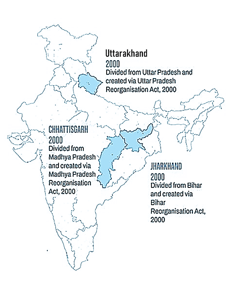
1. Chhattisgarh (Formed on 1 November 2000)
- Created from the eastern districts of Madhya Pradesh
- Resulted in a clearly defined separation in central India
- The map split Madhya Pradesh into two distinct regions
2. Jharkhand (Formed on 15 November 2000)
- Carved out of the southern region of Bihar
- Introduced a new state boundary in eastern India
- Reduced the geographical size of Bihar significantly
3. Uttarakhand (Formed on 9 November 2000)
(Initially named Uttaranchal)
- Formed from the northern mountainous districts of Uttar Pradesh
- Brought a new Himalayan state into the political map
- Created a distinct northern boundary separate from Uttar Pradesh
- In January 2007 (Act passed in 2006), the state of Uttaranchal was officially renamed Uttarakhand
| Year | Change Type | Map Impact |
|---|---|---|
| 2000 | Creation of 3 new states | Major boundary redraw |
| 2001–2005 | Boundary stabilization | Standardized map formats |
| 2006–2007 | State renaming | Label update on maps |
| 2007–2010 | Consolidation | Stable modern map structure |
Coastal Boundary Definition and Eastern Border Refinement
The political maps of India in the 1990s and 2000s reflect a consistently well-defined national outline, particularly along coastal regions and the eastern frontier. During this period, cartographic representation benefited from improved surveying techniques, satellite imagery, and standardized mapping practices, resulting in more precise and uniform boundary depiction.
Coastal Boundaries
India’s extensive coastline along the Arabian Sea and the Bay of Bengal is depicted with increasing geometric accuracy in maps of the 2000s. Coastal contours—especially along Gujarat, Maharashtra, Kerala, Tamil Nadu, and Odisha—show smoother alignment and more detailed curvature compared to earlier representations.
The island territories are also more clearly represented:
- Lakshadweep appears as a defined cluster of islands off the southwestern coast
- Andaman & Nicobar Islands are accurately aligned in the Bay of Bengal with improved spatial positioning
These refinements enhance visual clarity and ensure consistent placement across modern map formats.
Eastern Boundary with Bangladesh
The eastern boundary, particularly along West Bengal, Assam, Meghalaya, Tripura, and Mizoram, is depicted with greater precision in the 2000s maps. Improvements during this period include:
- More clearly aligned river-based boundary segments
- Smoother transitions along land boundaries
- Enhanced consistency in border curvature and detailing
These refinements result in a cleaner and more accurate representation of India’s eastern edge, contributing to a standardized and stable political map.