
Historical Maps of India Based on Ancient Literature
India’s historical geography is preserved not only through archaeological remains and inscriptions but also through a vast body of literary traditions. Ancient epics, Puranas, religious texts, royal chronicles, and travel accounts contain detailed references to rivers, mountains, kingdoms, pilgrimage centers, forests, and trade routes. Over the years, historians and scholars have used these descriptions to create reconstructed maps that attempt to visualize the Indian subcontinent as it may have appeared during different historical and mythological periods.
Unlike modern maps based on precise surveys and satellite imagery, these historical reconstructions are interpretive in nature. They combine literary references, archaeological findings, inscriptions, local traditions, and historical research to present a geographical understanding of ancient India.
Mapping the India of the Epics
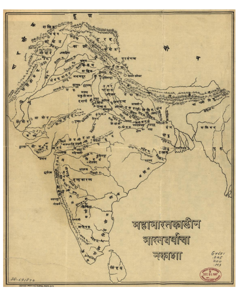
Some of the most fascinating historical maps are based on the Mahabharata and Ramayana. These maps identify ancient kingdoms, rivers, pilgrimage sites, forests, battlefields, and trade routes mentioned in the epics. Scholars have attempted to correlate these locations with present-day geography to better understand the political and cultural landscape described in the texts.
Maps depicting the Mahabharata period often show major kingdoms such as Hastinapura, Indraprastha, Panchala, Gandhara, Magadha, Kashi, Matsya, and Avanti, along with numerous rivers that played an important role in the narrative. Similarly, Ramayana-based maps trace the journey of Lord Rama across northern and southern India, identifying locations traditionally associated with events described in the epic.
Ancient maps often divided the region into “India Within the Ganges” and “India Beyond the Ganges,” reflecting the geographical understanding of the time. These early depictions helped shape European knowledge of South Asia for more than a millennium.
Puranic Geography and the Concept of Bharatavarsha
Ancient Puranic texts describe a vast cultural and geographical entity known as Bharatavarsha. Historical maps derived from these sources attempt to represent mountains, sacred rivers, regions, and kingdoms as understood by ancient Indian scholars. Such maps provide insights into how people of earlier times visualized the extent of their world and organized geographical knowledge.
These representations often highlight the central importance of rivers such as the Ganga, Yamuna, Saraswati, Narmada, Godavari, Krishna, and Kaveri, which served not only as physical landmarks but also as sacred and cultural corridors.
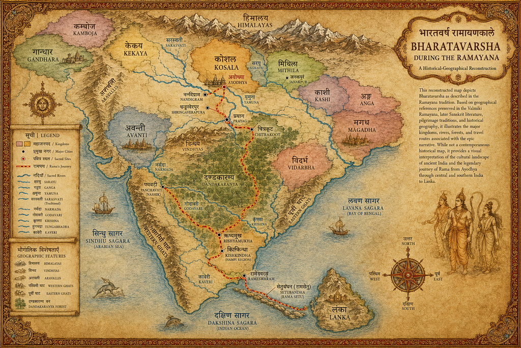
This illustrated map presents a historical-geographical reconstruction of Bharatavarsha as described in the Ramayana tradition. It traces Rama’s legendary journey from Ayodhya through Prayag, Chitrakoot, Dandakaranya, Panchavati, Kishkindha and Rameswaram to Lanka, while also identifying major kingdoms, sacred rivers, mountain ranges, forests and important cultural centres of the period. Designed in the style of an illuminated ancient manuscript, the map combines traditional place associations, literary references and historical geography to offer a visual interpretation of the epic landscape. It should be understood as a cultural and scholarly reconstruction rather than a contemporaneous historical map.
Reconstructing Ancient Kingdoms
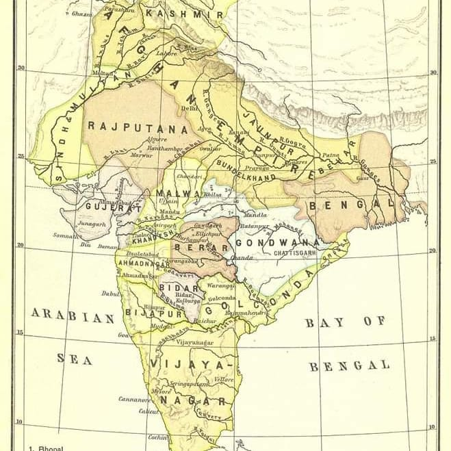
Historical maps based on literary and epigraphic evidence help illustrate the territorial extent of major dynasties and kingdoms. Using references from court chronicles, copper plate inscriptions, temple records, and literary works, scholars have reconstructed the geography of:
- Mahajanapadas
- Maurya Empire
- Gupta Empire
- Satavahana Kingdom
- Chola Empire
- Pallava Kingdom
- Vijayanagara Empire
- Mughal Empire
- Maratha Confederacy
These maps reveal shifting political boundaries and provide valuable insights into trade networks, military campaigns, and centers of administration.
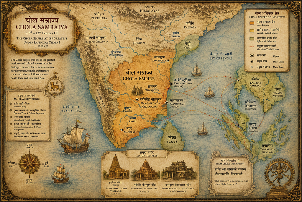
This illustrated map presents a historical-geographical reconstruction of the Chola Samrajya at the height of its power during the early eleventh century, particularly under Rajaraja Chola I and Rajendra Chola I. It highlights the empire’s core territories in southern India, important centres such as Thanjavur, Gangaikonda Cholapuram, Madurai, Kaveripattinam and Nagapattinam, and its maritime connections across the Bay of Bengal to Sri Lanka and Southeast Asia. The map also reflects the Cholas’ achievements in naval warfare, overseas trade, temple architecture, irrigation, administration and cultural expansion, represented through major temples, ports and sea routes. Designed in the style of an illuminated historical manuscript, it offers a visual interpretation of the Chola world rather than a precise contemporary political map.
Mapping Ancient Trade and Pilgrimage Networks
Many historical maps focus on the movement of people rather than political boundaries. Ancient India was connected through extensive trade and pilgrimage routes that linked distant regions of the subcontinent.
Literary sources describe commercial routes connecting northwestern India with Central Asia, coastal trade networks spanning the Indian Ocean, and pilgrimage circuits joining sacred sites across the country. Reconstructed maps help visualize these networks and demonstrate the remarkable level of connectivity that existed long before modern transportation systems.
The Value of Literary Maps
Historical maps based on ancient literature should not always be viewed as exact geographical records. Instead, they serve as visual interpretations of how different periods understood space, territory, and cultural identity. They allow readers to explore the landscapes described in epics, chronicles, and sacred texts while providing valuable context for India’s civilizational history.
These maps bridge the gap between history, mythology, archaeology, and geography, helping modern audiences appreciate how generations of scholars have interpreted India’s rich literary heritage. They offer a unique perspective on the evolution of Bharat, revealing not only where places were located but also how they were remembered, celebrated, and woven into the collective memory of the civilization.
Exploring India’s Historical Geography
The collection presented here brings together maps reconstructed from literary, historical, and traditional sources, offering a window into India’s past through the lens of geography. Whether depicting the world of the Mahabharata, the sacred landscape of the Puranas, or the domains of ancient kingdoms, these maps invite visitors to journey through the many layers of India’s historical imagination and cultural memory.